
This is free.
Improving small plantation and woodlot inventory using remote sensing - how you can help
Jonathan Dash and Michael Watt, New Zealand Tree Grower May 2017.

Small plantations and woodlots comprise around 36 per cent of the total New Zealand plantation estate. Growers of these woodlots include an estimated 14,000 small-scale and medium-scale forest owners and much of this vital resource is found on New Zealand’s farms. Accurate assessment of these forests is important for ensuring realistic valuation during forest transactions and to understand current and future wood availability at regional and national levels.
Forest valuation usually involves installing ground-based sample plots to estimate saleable volume separated by log grade.This may be too expensive for smaller plantations because these smaller forests usually vary a lot relative to their area and are of low total value compared to larger forests.As a result, not enough field plots may be installed and measured to keep costs down.
Insufficient plots can lead to inaccurate estimates of the forest value. Precision estimates obtained in this way, such as probable limit of error, may be misleading. As a result, log buyers or potential buyers may undervalue the resource to compensate for the high degree of uncertainty. On the other hand, an over-estimation of the value could lead to a poorer revenue at harvest with detrimental flow-on effects for rural businesses. This could lead to forestry being seen as a less viable investment for farming communities.
Improving the methods for estimating yields is important to support the management of small plantations and ensure the sustainability of this important wood source.A new two-year research programme initiated at Scion aims to do just that.
What are we going to do and why?
The project’s aim is to develop ways to integrate remotely-sensed data into forest inventories at an appropriate scale in a cost-effective manner. In other words, trying to make it cheaper and more appropriate for the owners of small-scale forests. Forest inventory techniques have been developed for larger plantations, but they are not necessarily suited to smaller forests. In our project we intend to develop new methods to allow for more precise and cost-effective estimates of the volume and value of small to medium-scale forests.
The research programme has several distinct themes, including re-using existing data where appropriate, providing methods for integrating newly collected data and focussing on developing unmanned aerial vehicles for forest inventory. At the end of the project we will have a set of options for small to medium-scale forest growers to assess their trees more accurately.
Laser scanning for forestry
Statistical techniques allow data from laser scanners on conventional aircraft to be integrated into forest inventories. These techniques are being applied across major commercial forests in New Zealand and Australia with considerable success and provide maximum benefits when they are applied to large forests. This is due to cost efficiencies in aerial data collection which can be achieved over larger areas and a requirement for a large number of field sample plots for statistical confidence.
UAVs for forest inventory
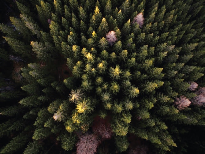
Unmanned aerial vehicles can help fill the gap between the area that can be assessed by an on-ground field crew and the areas which are typically assessed by satellite- based imaging or manned aircraft. The rapid development of relatively low-cost unmanned aerial vehicles and miniaturised sensors provide promising data collection opportunities for forest measurement. Three dimensional images of the forest canopy, useful for predicting forest inventory measurements, can be collected from laser scanners or from very densely overlapped imagery using a technique called structure from motion. Depending on the size, shape and characteristics of the subject forest, only partial coverage of the resource may be possible due to limitations in flying time and legal restrictions which limit flight height.
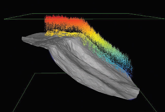
Extracting useful data from unmanned aerial vehicles requires special mathematical techniques. Methods for integrating this data into forest inventory are only just starting to be developed. Research from Scandinavia suggests that the improvements in accuracy and precision are significant compared to conventional methods, and can be cost effective compared to other forms of remote sensing. Working with our international collaborators, we aim to develop methods for incorporating unmanned aerial vehicle data into a practical forest inventory system designed for small plantations and woodlots. Carrying out a comprehensive case study will allow us to compare the value of using this data compared to traditional methods and suggest appropriate data collection and flight settings.
Involving owners of woodlots
In separate research we will investigate whether small to medium-scale forest growers can access the benefits of existing techniques by using a community-based method. We hope to collate a database of field plots from a group of participants who are willing to provide their data. Field plot data may be installed specifically by a user for this purpose or may be acquired from pre- existing sources such as permanent sample plots, already established forest inventory plots, or field measurement plots associated with the Emissions Trading Scheme. This database, along with freely available remotely sensed data frequently collected by regional or national government agencies, will provide reference data that will help with forest assessment for all participants.
The success of this method depends on people who are willing to participate and share their data which can be anonymous if required. If you are interested in helping with this research, think your small to medium sized forests could be a suitable location for fieldwork, or would like to become part of a community of users, we would love to hear from you. Please get in touch with Jonathan Dash by email at jonathan.dash@scionresearch.com. We will be presenting our research results via seminars and articles in both scientific and industry publications in 2018.
The work is being supported by AgMardt, Forest Growers Levy Trust, New Zealand Farm Forestry Association, The Neil Barr Foundation and Scion’s core funding.
Jonathan Dash and Michael Watt are researchers in the Geomatics group at Scion.